Docs Home → Develop Applications → Atlas Device SDKs
Geospatial Data - Kotlin SDK
On this page
New in version 1.11.0.
Geospatial data, or "geodata", specifies points and geometric objects on the Earth's surface.
Kotlin SDK version 1.11.0 and later adds experimental geospatial APIs that support querying with geospatial data. These queries can check whether a given point is contained within a shape. For example, you can find all coffee shops within 15 km of a specified point.
Changed in version 1.13.0: Geospatial data supported in Atlas Device Sync
Kotlin SDK version 1.13.0 and later adds support for geospatial data in Atlas Device Sync. This allows you to subscribe to geospatial queries in a synced realm. If you try to subscribe to a geospatial query with an older version of the SDK, you will receive a server error with a compensating write.
For more information about managing your Sync subscriptions, refer to Manage Sync Subscriptions - Kotlin SDK.
For more information on querying geospatial data with Device Sync, refer to Geospatial Data in the App Services documentation.
Geospatial Data Types
The Kotlin SDK supports geospatial queries using the following data types:
GeoPoint
GeoCircle
GeoBox
GeoPolygon
The SDK provides these geospatial data types to simplify querying geospatial data. You cannot persist these data types directly.
For information on how to persist geospatial data, refer to the Persist Geospatial Data section on this page.
GeoPoint
A GeoPoint defines a specific
location on the Earth's surface. All of the geospatial data types use GeoPoints
to define their location.
GeoCircle
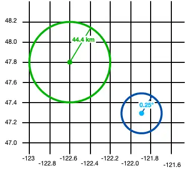
A GeoCircle defines a circle on
the Earth's surface. You define a GeoCircle by providing a GeoPoint
for the center of the circle and a Distance
object to specify the radius of the circle.
Note
You can define the radius in kilometers, miles, degrees, or radians.
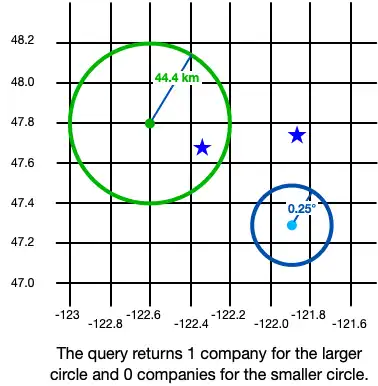
The following example creates 2 circles:
val circle1 = GeoCircle.create( center = GeoPoint.create(47.8, -122.6), radius = Distance.fromKilometers(44.4) ) val circle2 = GeoCircle.create( center = GeoPoint.create(47.3, -121.9), radius = Distance.fromDegrees(0.25) )

GeoBox
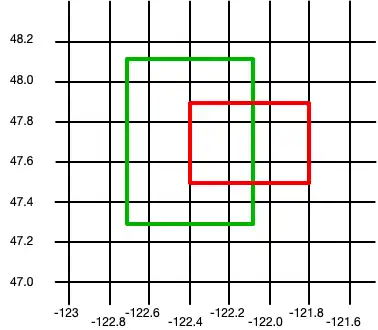
A GeoBox defines a rectangle on the Earth's surface. You define the rectangle by specifying the bottom left (southwest) corner and the top right (northeast) corner.
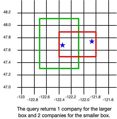
The following example creates 2 boxes:
val box1 = GeoBox.create( bottomLeft = GeoPoint.create(47.3, -122.7), topRight = GeoPoint.create(48.1, -122.1) ) val box2 = GeoBox.create( bottomLeft = GeoPoint.create(47.5, -122.4), topRight = GeoPoint.create(47.9, -121.8) )

GeoPolygon
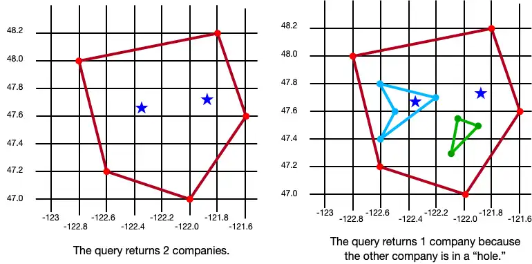
A GeoPolygon defines a polygon on the Earth's surface.
Because a polygon is a closed shape, you must provide a minimum of 4 points: 3 points to define the polygon's shape and a fourth to close the shape.
Important
The fourth point in a polygon must be the same as the first point.
You can also exclude areas within a polygon by defining one or more "holes". A hole is another polygon whose bounds fit completely within the outer polygon. Holes can also be nested within each other. A location is considered inside the polygon if it is included in an odd number of rings.
The following example creates 3 polygons:
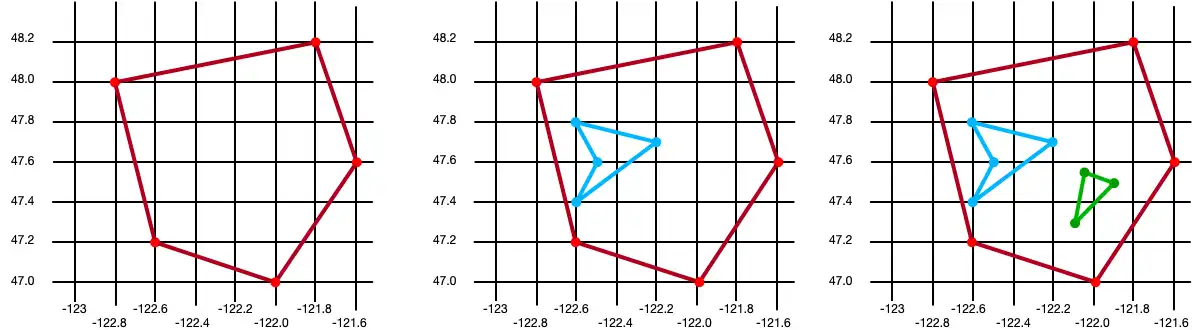
A basic polygon with 5 points
The same polygon with a single hole
The same polygon with two holes
// Create a basic polygon val basicPolygon = GeoPolygon.create( listOf( GeoPoint.create(48.0, -122.8), GeoPoint.create(48.2, -121.8), GeoPoint.create(47.6, -121.6), GeoPoint.create(47.0, -122.0), GeoPoint.create(47.2, -122.6), GeoPoint.create(48.0, -122.8) ) ) // Create a polygon with a single hole val outerRing = listOf( GeoPoint.create(48.0, -122.8), GeoPoint.create(48.2, -121.8), GeoPoint.create(47.6, -121.6), GeoPoint.create(47.0, -122.0), GeoPoint.create(47.2, -122.6), GeoPoint.create(48.0, -122.8) ) val hole1 = listOf( GeoPoint.create(47.8, -122.6), GeoPoint.create(47.7, -122.2), GeoPoint.create(47.4, -122.6), GeoPoint.create(47.6, -122.5), GeoPoint.create(47.8, -122.6) ) val polygonWithOneHole = GeoPolygon.create(outerRing, hole1) // Add a second hole to the polygon val hole2 = listOf( GeoPoint.create(47.55, -122.05), GeoPoint.create(47.5, -121.9), GeoPoint.create(47.3, -122.1), GeoPoint.create(47.55, -122.05) ) val polygonWithTwoHoles = GeoPolygon.create(outerRing, hole1, hole2)

Persist Geospatial Data
Important
Cannot Persist Geospatial Data Types
Currently, you can only persist geospatial data. Geospatial data types cannot be persisted directly. For example, you
can't declare a property that is of type GeoBox.
These types can only be used as arguments for geospatial queries.
If you want to persist geospatial data, it must conform to the GeoJSON spec.
To do this with the Kotlin SDK, you can create a GeoJSON-compatible embedded class that you can then use in your data model.
Create a GeoJSON-Compatible Class
To create a class that conforms to the GeoJSON spec, you:
Create an embedded realm object (a class that inherits from EmbeddedRealmObject).
At a minimum, add the two fields required by the GeoJSON spec:
A field of type
Stringproperty that maps to atypeproperty with the value of"Point":var type: String = "Point"A field of type
RealmList<Double>that maps to acoordinatesproperty in the realm schema containing a latitude/longitude pair:var coordinates: RealmList<Double> = realmListOf()
The following example shows an embedded class named CustomGeoPoint that is used
to persist geospatial data:
class CustomGeoPoint : EmbeddedRealmObject { constructor(latitude: Double, longitude: Double) { coordinates.apply { add(longitude) add(latitude) } } // Empty constructor required by Realm constructor() : this(0.0, 0.0) // Name and type required by Realm var coordinates: RealmList<Double> = realmListOf() // Name, type, and value required by Realm private var type: String = "Point" var latitude: Double get() = coordinates[1] set(value) { coordinates[1] = value } var longitude: Double get() = coordinates[0] set(value) { coordinates[0] = value } }
Use the Embedded Class
Use the customGeoPoint class in your realm model, as shown in the
following example:
class Company : RealmObject { var _id: ObjectId = ObjectId() var location: CustomGeoPoint? = null }
You can then add instances of your class to the realm:
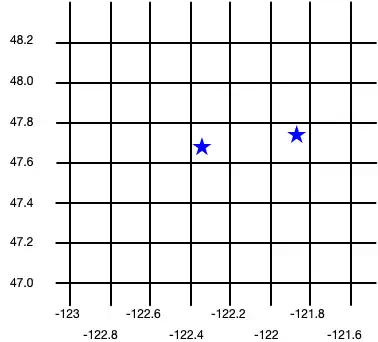
realm.writeBlocking { copyToRealm( Company().apply { location = CustomGeoPoint(47.68, -122.35) } ) copyToRealm( Company().apply { location = CustomGeoPoint(47.9, -121.85) } ) }
The following image shows the results of creating these two Company objects:

Query Geospatial Data
To query against geospatial data, you can use the GEOWITHIN operator with
RQL. This method takes the coordinates
property of an embedded object and checks if that point is contained within
the geospatial shape for that object.
The format for querying geospatial data is the same, regardless of the shape of the geodata region.
Important
You cannot use parameterized queries with geospatial data.
The following examples show querying against various shapes to return a list of companies within the shape.
GeoCircle
val companiesInLargeCircle = realm.query<Company>("location GEOWITHIN $circle1").find() println("Companies in large circle: ${companiesInLargeCircle.size}") val companiesInSmallCircle = realm.query<Company>("location GEOWITHIN $circle2").find() println("Companies in small circle: ${companiesInSmallCircle.size}")
Companies in large circle: 1 Companies in small circle: 0

GeoBox
val companiesInLargeBox = realm.query<Company>("location GEOWITHIN $box1").find() println("Companies in large box: ${companiesInLargeBox.size}") val companiesInSmallBox = realm.query<Company>("location GEOWITHIN $box2").find() println("Companies in small box: ${companiesInSmallBox.size}")
Companies in large box: 1 Companies in small box: 2

GeoPolygon
val companiesInBasicPolygon = realm.query<Company>("location GEOWITHIN $basicPolygon").find() println("Companies in basic polygon: ${companiesInBasicPolygon.size}") val companiesInPolygonWithHoles = realm.query<Company>("location GEOWITHIN $polygonWithTwoHoles").find() println("Companies in polygon with holes: ${companiesInPolygonWithHoles.size}")
Companies in basic polygon: 2 Companies in polygon with holes: 1