Overview
MongoDB supports the GeoJSON object types listed on this page.
To specify GeoJSON data, use an embedded document with:
a field named
typethat specifies the GeoJSON object type, anda field named
coordinatesthat specifies the object's coordinates.
<field>: { type: <GeoJSON type> , coordinates: <coordinates> }
Important
If specifying latitude and longitude coordinates, list the longitude first, and then latitude.
Valid longitude values are between
-180and180, both inclusive.Valid latitude values are between
-90and90, both inclusive.
MongoDB geospatial queries on GeoJSON objects calculate on a sphere; MongoDB uses the WGS84 reference system for geospatial queries on GeoJSON objects.
Point
The following example specifies a GeoJSON Point:
{ type: "Point", coordinates: [ 40, 5 ] }
LineString
The following example specifies a GeoJSON LineString:
{ type: "LineString", coordinates: [ [ 40, 5 ], [ 41, 6 ] ] }
Polygon
Polygons consist of an array of GeoJSON LinearRing coordinate arrays. A LinearRing is a closed LineString with at least four coordinate pairs. The first and last coordinates must be identical.
Lines between two points on a curved surface, or geodesics, can differ from lines between the same points on a flat surface. Check coordinates carefully to avoid shared-edge errors, overlaps, or other intersections.
Polygons with a Single Ring
The following example specifies a GeoJSON Polygon with an exterior ring and no interior rings (or holes). The first and last coordinates must match in order to close the polygon:
{ type: "Polygon", coordinates: [ [ [ 0 , 0 ] , [ 3 , 6 ] , [ 6 , 1 ] , [ 0 , 0 ] ] ] }
For Polygons with a single ring, the ring cannot self-intersect.
Polygons with Multiple Rings
For Polygons with multiple rings:
The first described ring must be the exterior ring.
The exterior ring cannot self-intersect.
Any interior ring must be entirely contained by the outer ring.
Interior rings cannot intersect or overlap each other. Interior rings cannot share an edge.
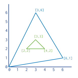
The following example represents a GeoJSON polygon with an interior ring:
{ type : "Polygon", coordinates : [ [ [ 0 , 0 ] , [ 3 , 6 ] , [ 6 , 1 ] , [ 0 , 0 ] ], [ [ 2 , 2 ] , [ 3 , 3 ] , [ 4 , 2 ] , [ 2 , 2 ] ] ] }
MultiPoint
Requires 2dsphere Indexes.
GeoJSON MultiPoint embedded documents encode a list of points.
{ type: "MultiPoint", coordinates: [ [ -73.9580, 40.8003 ], [ -73.9498, 40.7968 ], [ -73.9737, 40.7648 ], [ -73.9814, 40.7681 ] ] }
MultiLineString
Requires 2dsphere Indexes.
The following example specifies a GeoJSON MultiLineString:
{ type: "MultiLineString", coordinates: [ [ [ -73.96943, 40.78519 ], [ -73.96082, 40.78095 ] ], [ [ -73.96415, 40.79229 ], [ -73.95544, 40.78854 ] ], [ [ -73.97162, 40.78205 ], [ -73.96374, 40.77715 ] ], [ [ -73.97880, 40.77247 ], [ -73.97036, 40.76811 ] ] ] }
MultiPolygon
Requires 2dsphere Indexes.
The following example specifies a GeoJSON MultiPolygon:
{ type: "MultiPolygon", coordinates: [ [ [ [ -73.958, 40.8003 ], [ -73.9498, 40.7968 ], [ -73.9737, 40.7648 ], [ -73.9814, 40.7681 ], [ -73.958, 40.8003 ] ] ], [ [ [ -73.958, 40.8003 ], [ -73.9498, 40.7968 ], [ -73.9737, 40.7648 ], [ -73.958, 40.8003 ] ] ] ] }
GeometryCollection
Requires 2dsphere Indexes.
The following example stores coordinates of GeoJSON type GeometryCollection:
{ type: "GeometryCollection", geometries: [ { type: "MultiPoint", coordinates: [ [ -73.9580, 40.8003 ], [ -73.9498, 40.7968 ], [ -73.9737, 40.7648 ], [ -73.9814, 40.7681 ] ] }, { type: "MultiLineString", coordinates: [ [ [ -73.96943, 40.78519 ], [ -73.96082, 40.78095 ] ], [ [ -73.96415, 40.79229 ], [ -73.95544, 40.78854 ] ], [ [ -73.97162, 40.78205 ], [ -73.96374, 40.77715 ] ], [ [ -73.97880, 40.77247 ], [ -73.97036, 40.76811 ] ] ] } ] }