Overview
In this guide, you can learn how to query geospatial data by using the Scala driver. You can also learn about different geospatial data formats supported by MongoDB.
Geospatial data represents a geographical location on the surface of the Earth. Examples of geospatial data include:
Locations of movie theaters
Borders of countries
Routes of bicycle rides
Dog exercise areas in New York City
Sample Data
The examples in this guide use the theaters collection in the sample_mflix database from the Atlas sample datasets. To access this collection from your Scala application, create a MongoClient that connects to an Atlas cluster and assign the following values to your database and collection variables:
val database: MongoDatabase = mongoClient.getDatabase("sample_mflix") val collection: MongoCollection[Document] = database.getCollection("theaters")
To learn how to create a free MongoDB Atlas cluster and load the sample datasets, see the MongoDB Get Started guide.
Coordinates on Earth
To store and query your geospatial data in MongoDB, use GeoJSON. GeoJSON is a data format created by the Internet Engineering Task Force (IETF).
Here is the location of MongoDB headquarters in GeoJSON:
"location" : { "type": "Point", "coordinates": [-73.986805, 40.7620853] }
For definitive information on GeoJSON, see the official IETF specification.
GeoJSON Positions
A position represents a single place on Earth and is given as an array containing two or three number values:
Longitude in the first position (required)
Latitude in the second position (required)
Elevation in the third position (optional)
Important
Longitude then Latitude
GeoJSON orders coordinates as longitude first and latitude second. This may be surprising as geographic coordinate system conventions generally list latitude first and longitude second. Make sure to check what format any other tools you are working with use. Popular tools such as OpenStreetMap and Google Maps list coordinates as latitude first and longitude second.
GeoJSON Types
Your GeoJSON object's type determines its geometric shape. Geometric shapes are made up of positions.
Here are some common GeoJSON types and how you can specify them with positions:
Point: Single position. This could represent the location of a sculpture.LineString: Array of two or more positions, thus forming a series of line segments. This could represent the route of the Great Wall of China.Polygon: Array of positions in which the first and last position are the same, enclosing some space. This could represent the land within Vatican City.
To learn more about the shapes you can use in MongoDB, see GeoJSON in the Server manual.
Index
To create a 2dsphere index, use the Indexes.geo2dsphere() helper to create a specification for the 2dsphere index. Pass the specification to the MongoCollection.createIndex() method to create the index.
The following example creates a 2dsphere index on the "location.geo" field in the theaters collection:
val indexObservable = collection.createIndex(Indexes.geo2dsphere("location.geo")) Await.result(indexObservable.toFuture(), Duration(10, TimeUnit.SECONDS))
To learn more about indexes in the Scala driver, see the Optimize Queries by Using Indexes guide.
Coordinates on a 2D Plane
You can store geospatial data using x and y coordinates on a two-dimensional Euclidean plane. Coordinates on a two-dimensional plane are called legacy coordinate pairs.
Legacy coordinate pairs have the following structure:
{ "location" : [ x, y ] }
The field value contains an array of two values in which the first represents the x axis value and the second represents the y axis value.
Index
To query data stored as legacy coordinate pairs, you must add the field containing legacy coordinate pairs to a 2d index. The following snippet creates a 2d index on the coordinates field by using the Indexes object:
val indexObservable = collection.createIndex(Indexes.geo2d("coordinates")) Await.result(indexObservable.toFuture(), Duration(10, TimeUnit.SECONDS))
To learn more about indexes in the Scala driver, see the Optimize Queries by Using Indexes guide.
For more information on legacy coordinate pairs, see the Legacy Coordinate Pairs section of the Geospatial Queries guide in the Server manual.
Tip
Supported Operators
Spherical (2dsphere) and flat (2d) indexes support some, but not all, of the same query operators. To view a full list of operators and their index compatibility, see the Geospatial Query
Operators section of the Geospatial Queries guide in the Server manual.
Geospatial Queries
Geospatial queries consist of a query operator and GeoJSON shapes as query parameters.
Query Operators
To query your geospatial data, use one of the following query operators:
$near$geoWithin$nearSphere$geoIntersectsrequires a 2dsphere index
You can specify these query operators in the Scala driver with the near(), geoWithin(), nearSphere(), and geoIntersects() methods of the Filters object.
To learn more about geospatial query operators, see the Geospatial Query Operators section of the Geospatial Queries guide in the Server manual.
To view a full list of Filters helper methods, see the Filters API documentation.
Query Parameters
To specify a shape to use in a geospatial query, use the Position, Point, LineString, and Polygon classes from the Scala driver.
To learn more about the GeoJSON shape classes, see the GeoJSON package API Documentation.
Geospatial Query Examples
The following examples use the MongoDB Atlas theaters collection in the sample_mflix sample database. You can learn how to set up your own free-tier Atlas cluster and how to load the sample dataset in the Get Started with the Scala Driver guide.
The examples in this section require the following imports:
import org.mongodb.scala.* import org.mongodb.scala.model.Indexes import org.mongodb.scala.model.Filters import org.mongodb.scala.model.Projections import com.mongodb.client.model.geojson.{Point, Polygon, Position} import java.util.Arrays import java.util.concurrent.TimeUnit import scala.concurrent.Await import scala.concurrent.duration.Duration
The theaters collection already contains a 2dsphere index on the location.geo field.
Query by Proximity
To search for and return documents from nearest to farthest from a point, use the near() method of the Filters object. The near() method constructs a query with the $near query operator.
The following example returns documents that are at most 1000 meters from the specified GeoJSON Point instance, sorted from nearest to farthest:
val refPoint = new Point(new Position(-73.986805, 40.7620853)) val findObservable = collection.find(Filters.near("location.geo", refPoint, Some(1000.0), Some(0.0))) val results = Await.result(findObservable.toFuture(), Duration(10, TimeUnit.SECONDS))
Tip
MongoDB uses the same reference system as GPS satellites to calculate geometries over the Earth.
To learn more about the $near operator, see the $near reference in the Server manual.
Query Within a Range
To search for geospatial data within a specified shape, use the geoWithin() method of the Filters object. The geoWithin() method constructs a query with the $geoWithin query operator.
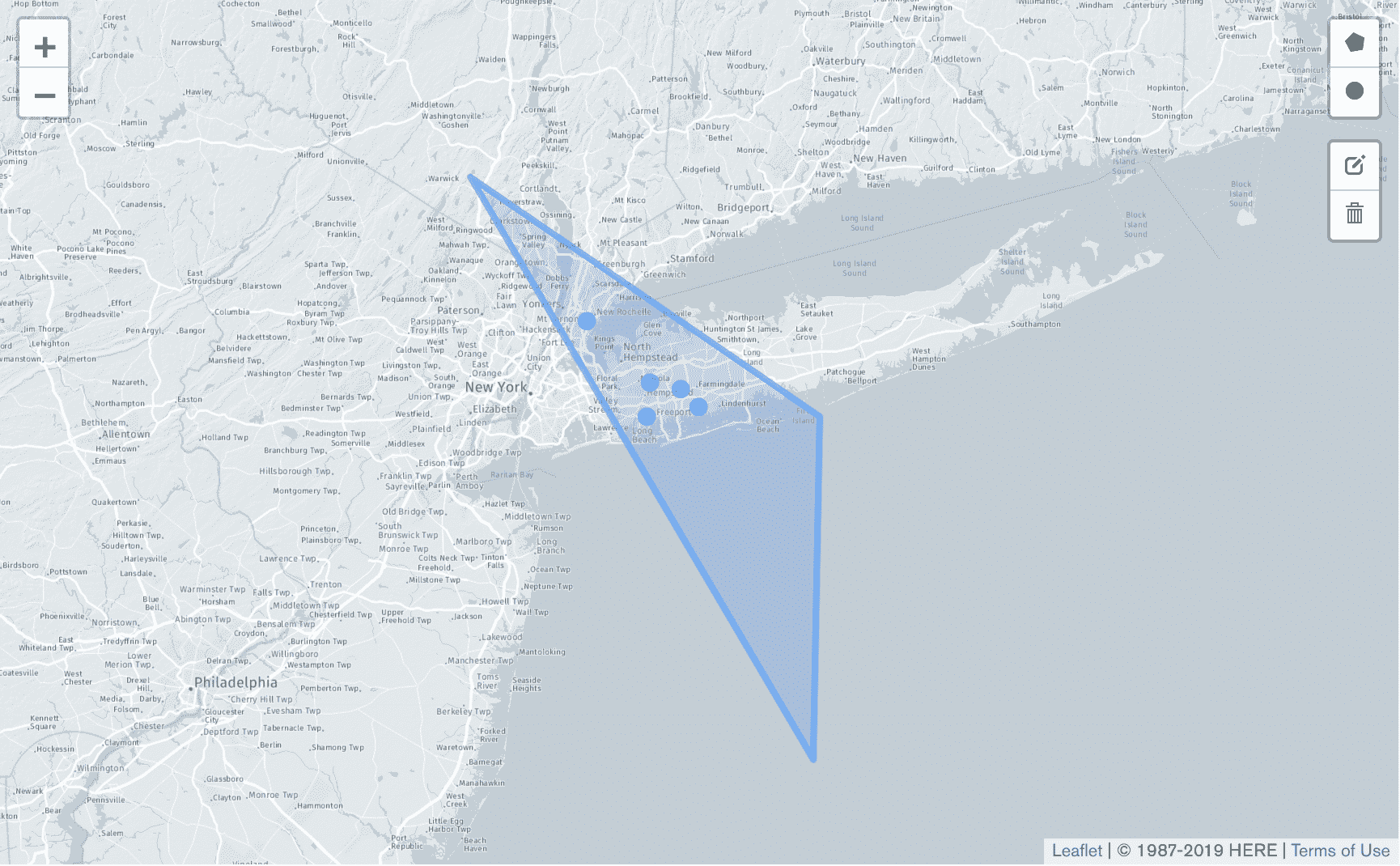
The following example searches for movie theaters in a section of Long Island. The example applies a projection so that each result includes only the location.address.city field and excludes the _id field:
val longIslandTriangle = new Polygon(Arrays.asList( new Position(-72.0, 40.0), new Position(-74.0, 41.0), new Position(-72.0, 39.0), new Position(-72.0, 40.0) )) val projection = Projections.fields( Projections.include("location.address.city"), Projections.excludeId() ) val geoWithinComparison = Filters.geoWithin("location.geo", longIslandTriangle) val findObservable = collection.find(geoWithinComparison).projection(projection) val results = Await.result(findObservable.toFuture(), Duration(10, TimeUnit.SECONDS)) results.foreach(doc => println(doc.toJson()))
The following figure shows the polygon defined by the longIslandTriangle variable and dots representing the locations of the movie theaters that the query returns.
To learn more about the $geoWithin operator, see the $geoWithin reference in the Server manual.
Additional Information
To learn more about performing geospatial queries, see Geospatial Queries in the Server manual.