Location Geofencing with MongoDB, Stitch, and Mapbox
Rate this tutorial
Please note: This article discusses Stitch. Stitch is now MongoDB Realm.
All the same features and functionality, now with a new name. Learn more
here. We will be updating this article
in due course.
For a lot of organizations, when it comes to location, geofencing is
often a very desirable or required feature. In case you're unfamiliar, a
geofence can be thought of as a virtual perimeter for a geographic area.
Often, you'll want to know when something enters or exits that geofence
so that you can apply your own business logic. Such logic might include
sending a notification or updating something in your database.
MongoDB supports GeoJSON data and offers quite a few operators that make
working the location data easy.
When it comes to geofencing, why would you want to use a database like
MongoDB rather than defining boundaries directly within your
client-facing application? Sure, it might be easy to define and manage
one or two boundaries, but when you're working at scale, checking to see
if something has exited or entered one of many boundaries could be a
hassle.
In this tutorial, we're going to explore the
$near
and
$geoIntersects
operators within MongoDB to define geofences and see if we're within the
fences. For the visual aspect of things, we're going to make use of
Mapbox for showing our geofences and our
location.
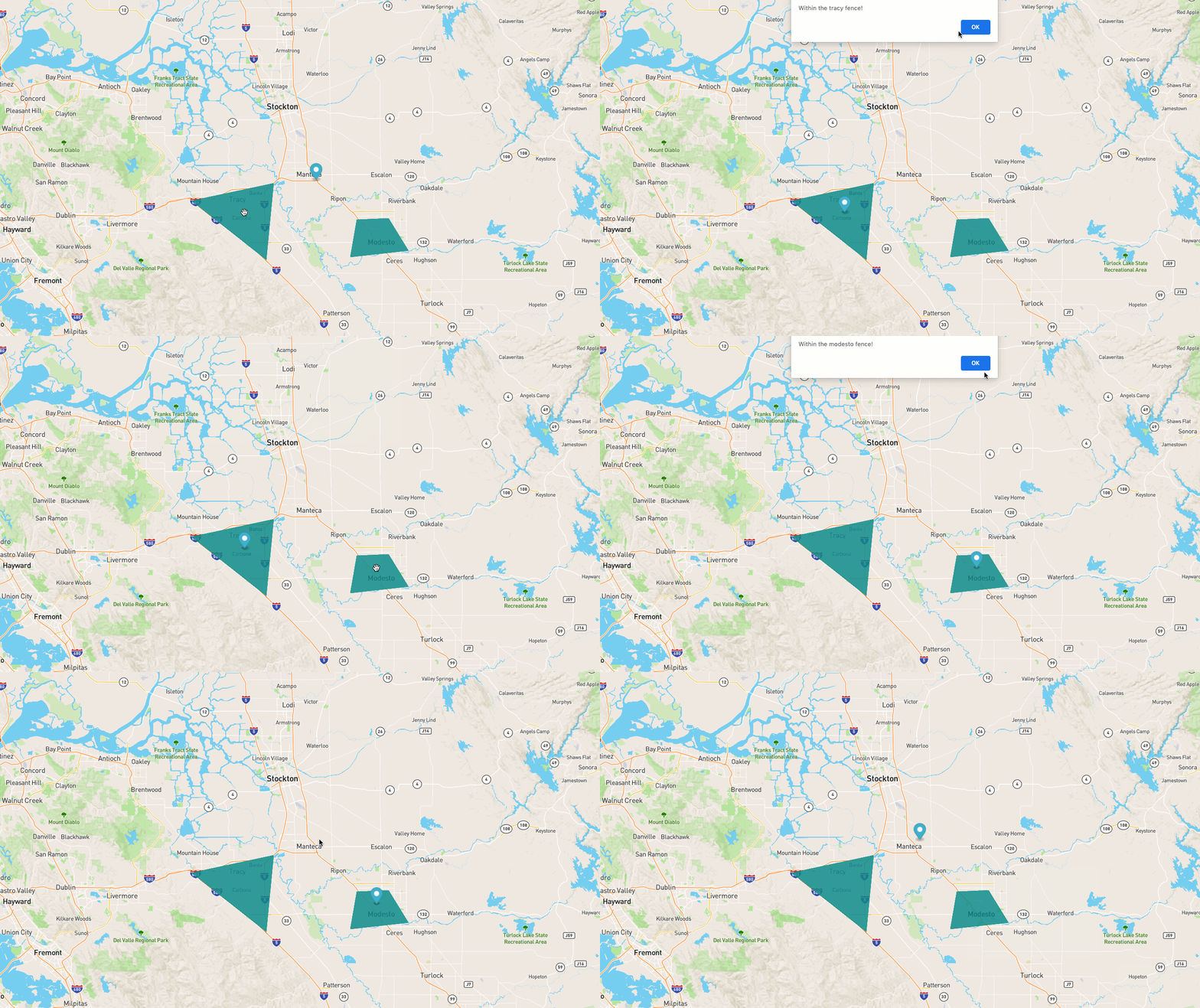
To get an idea of what we're going to build, take a look at the
following animated image:

We're going to implement functionality where a map is displayed and
polygon shapes are rendered based on data from within MongoDB. When we
move the marker around on the map to simulate actual changes in
location, we're going to determine whether or not we've entered or
exited a geofence.
There are a few moving pieces for this particular tutorial, so it is
important that the prerequisites are met prior to starting:
- Must have a Mapbox account with an access token generated.
- Must have a MongoDB Atlas cluster available.
Mapbox is a service, not affiliated with MongoDB. To render a map along
with shapes and markers, an account is necessary. For this example,
everything can be accomplished within the Mapbox free tier.
Because we'll be using MongoDB Stitch in connection with Mapbox, we'll
need to be using MongoDB Atlas.
MongoDB Atlas can be used to deploy an M0
sized cluster of MongoDB for FREE.
The MongoDB Atlas cluster should have a location_services database
with a geofences collection.
To use the geospatial functionality that MongoDB offers, the data stored
within MongoDB must be valid GeoJSON data. At the end of the day,
GeoJSON is still JSON, which plays very nicely with MongoDB, but there
is a specific schema that must be followed. To learn more about GeoJSON,
visit the specification documentation.
For our example, we're going to be working with Polygon and Point data.
Take the following document model:
In the above example, the
region represents our GeoJSON data and
everything above it such as name represents any additional data that
we want to store for the particular document. A realistic example to the
above model might look something like this:We're naming any of our possible fenced regions. This could be useful to
a lot of organizations. For example, maybe you're a business with
several franchise locations. You could geofence the location and name it
something like the address, store number, etc.
To get the performance we need from our geospatial data and to be able
to use certain operators, we're going to need to create an index on our
collection. The index looks something like the following:
The index can be created through Atlas, Compass, and with the CLI. The
goal here is to make sure the
region field is a 2dsphere index.Rather than creating a backend application to interact with the
database, we're going to make use of MongoDB Stitch. Essentially, the
client-facing application will use the Stitch SDK to authenticate before
interacting with the data.
Within the MongoDB Cloud, choose to create
a new Stitch application if you don't already have one that you wish to
use. Make sure that the application is using the cluster that has your
geofencing data.

Within the Stitch dashboard, choose the Rules tab and create a new
set of permissions for the geofences collection. For this particular
example, the Users can only read all data permission template is
fine.
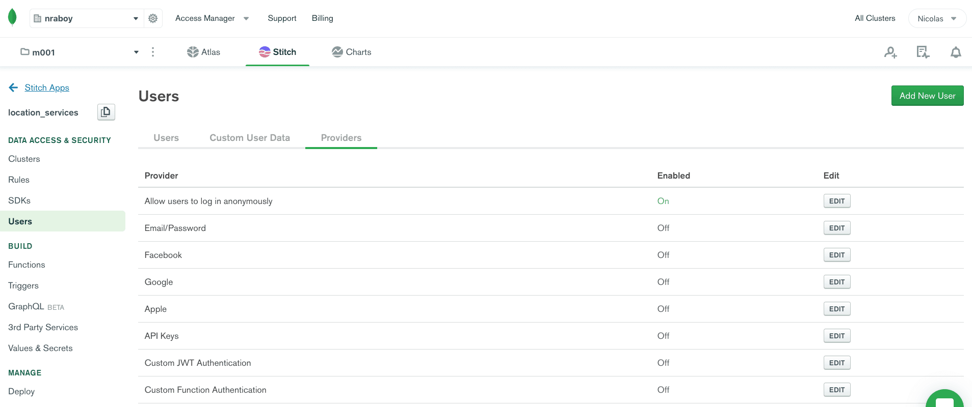
Next, we'll want to choose an authentication mechanism. In the Users
tab, choose Providers, and enable the anonymous authentication
provider. In a more realistic production scenario, you'll likely want to
create geofences that have stricter users and rules design.

Before moving onto actually creating an application, make note of your
App ID within Stitch, as it will be necessary for connecting.
With all the configuration out of the way, we can move into the fun part
of creating an attractive client-facing application that queries the
geospatial data in MongoDB and renders it on a map.
On your computer, create an index.html file with the following
boilerplate code:
In the above HTML, we're importing the Mapbox and MongoDB Stitch SDKs,
and we are defining an HTML container to hold our interactive map.
Interacting with MongoDB and the map will be done in the
<script> tag
that follows.Within the
<script> tag, the first things we want to accomplish are
around connecting to MongoDB Stitch and configuring map:The map should be centered somewhere around Tracy, CA, and MongoDB
Stitch was configured to use the location_services database. Make
sure to swap the tokens with your actual Mapbox and Stitch tokens.
The next step is to populate the map with markers and polygons when it
loads:
In the above
load event, we are creating a marker somewhere outside
the center of the map and one single polygon shape. The thing is, we
don't want to hard-code our polygon shapes that represent geofence
regions. Instead, add the GeoJSON data to MongoDB along with other
possible fences.We can change our
load event to the following:In the above code, we query our collection for all documents and add
them each as a layer on the map. We can do better though. In the above
example, the geofences amount could be quite large and it doesn't
necessarily make sense to show all the fences that aren't even remotely
close to the current location. This would slow down the application for
the client.
Instead, we can change the query to the following:
In the above code, we're saying that we only want geofence results that
are within 50,000 meters of our center point coordinate set. While our
example doesn't have many documents, this could be very beneficial in
terms of performance.
Depending on the geofence data in MongoDB, you likely have some polygons
drawn on the map as well as your marker. The next step is to move the
marker around to simulate a change in location. We can do this with the
click event for Mapbox:In the above code we make use of the
$geoIntersects operator in our
query. What this is doing is returning all documents where our point
sits within the polygon shape. The marker is updated to wherever the map
was clicked.If there is an intersection, we just print out the first result to an
alert. We do this because there could be overlapping geofences and for
the scope of this example, we don't need to worry about that.
You just saw how to leverage MongoDB and its ability to do geospatial
queries to create geofences for a maps and location services type
application. In the application we built, we stored GeoJSON data within
MongoDB and queried for it using the
$near and $geoIntersects
operators. This allowed us to figure out what data we wanted based on a
point location. We made use of Mapbox to give us a visual element as to
whether or not our queries would return data.